Automated Drone System for Disaster Response: The Hugin Project at TU Braunschweig
The Technische Universität Braunschweig is pioneering an automated reconnaissance system to assist disaster response personnel. At the heart of this system is the drone Hugin, equipped with a Manta G-917 camera from Allied Vision. These drones provide real-time data and aerial images to ground-based systems, enabling first responders to make quick and informed decisions that would otherwise be unavailable.
Complex Situations Under Time Pressure
Heavy rain and storms have led to increased flooding in recent years. When large volumes of rain fall in a short time, water overflows sewage systems and rises above riverbanks, often causing destructive effects. Emergency responders face the challenge of coordinating aid efficiently in these inaccessible areas. Real-time aerial data combined with ground sensor information can provide critical insights for decision-making.
Based on this imagery, emergency teams can answer vital questions—such as whether warnings or closures are needed, where sandbags should be placed, and which routes remain accessible. In the future, the Braunschweig Stadtentwässerung aims to use the TU Braunschweig system for long-term monitoring of flood protection measures and reviewing predictive models.
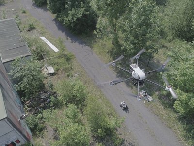
The Automated Exploration System
Engineers from the Institute of Flight Guidance at Technische Universität Braunschweig (TUBS) have developed an automated exploration system with support from the DLR Space Administration. This project, funded by approximately one million euros from the Federal Ministry of Economics and Energy, involves collaboration with AirRobot GmbH & Co. KG.
The system uses unmanned aerial vehicles to capture aerial imagery in disaster zones like flood areas. The Manta G-917 camera provides high-resolution images that, combined with ground-based systems, offer a comprehensive view for emergency responders.
User-Friendly Operation
For emergency situations, the system prioritizes speed and simplicity. Flight paths can be determined quickly based on simple parameters, making drone control straightforward. Users simply select an area at the ground station, and automated flight planning handles overlapping images needed for photogrammetric processing.
Once airborne, the drone follows its path automatically while providing automatic image evaluation—live or otherwise—to support decision-making in real time.
Maintaining Overview Through Automatic Processing
During flights, images are captured from altitudes around 100 meters. These images undergo automated processing to generate a continuous overview of the affected area. The camera’s built-in functions handle exposure adjustments and preprocessing (image optimization, light correction, etc.), ensuring rich two-dimensional images are sent directly to ground stations.
A local communication network facilitates efficient data transfer between devices during emergencies. This enables emergency responders to quickly assess situations more effectively by having access to detailed imagery of critical locations.
High-Performance Camera Specifications
The system relies on Allied Vision’s Manta G-917 camera, equipped with a 1” Sony ICX814 CCD sensor featuring EXview HAD II technology and offering 9.2 megapixels resolution. Its outstanding image quality allows detailed ground object inspection.
Key features include an ethernet connection for reliable data transfer and global shutter sensor technology to prevent motion blur during high-speed imaging.
Key Features of the Manta Camera
- Provides real-time data and images, enabling rapid decision-making.
- Supports rescue operations through aerial imagery analysis.
- Delivers rich two-dimensional images even under challenging conditions.
Last Updated: 2025-09-04 17:08:02